PG&E recreational areas

Visit California hiking trails, including Point Bouchon Trail and Pecho Coast Trail, campgrounds and day-use areas

Campgrounds and Day-use areas

Recreational areas

From the Pit River country in the Cascade Range to the coast of San Luis Obispo County, our recreational facilities are ready for you to enjoy.

Locations such as Lake Almanor, Lake Spaulding and Lake Britton, are engineered to create clean energy through our hydroelectric system. Our sites feature campground and picnic facilities located throughout the Sierra Nevada available for reservation. Most of the lakes also offer fishing, swimming and boating.

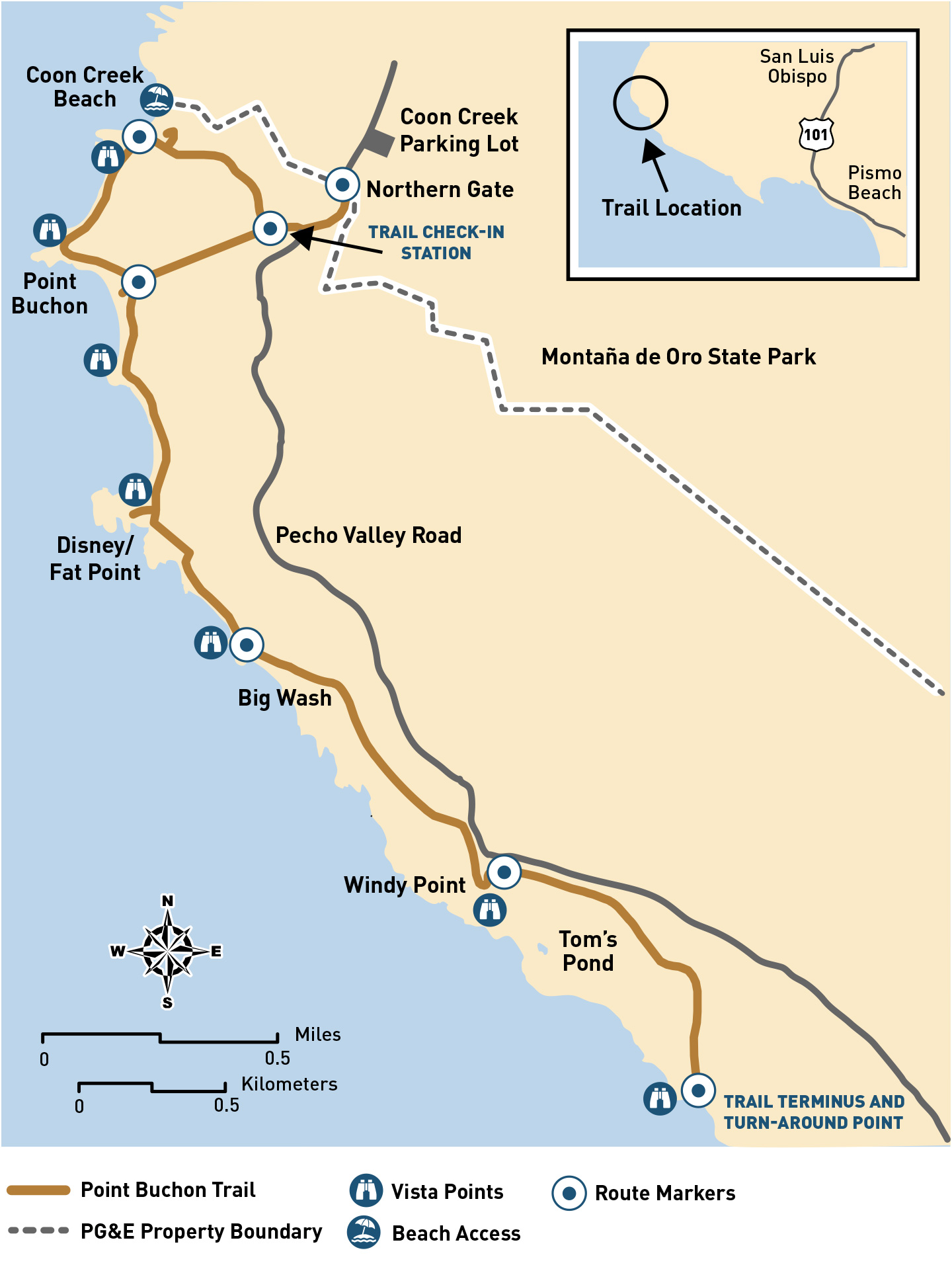
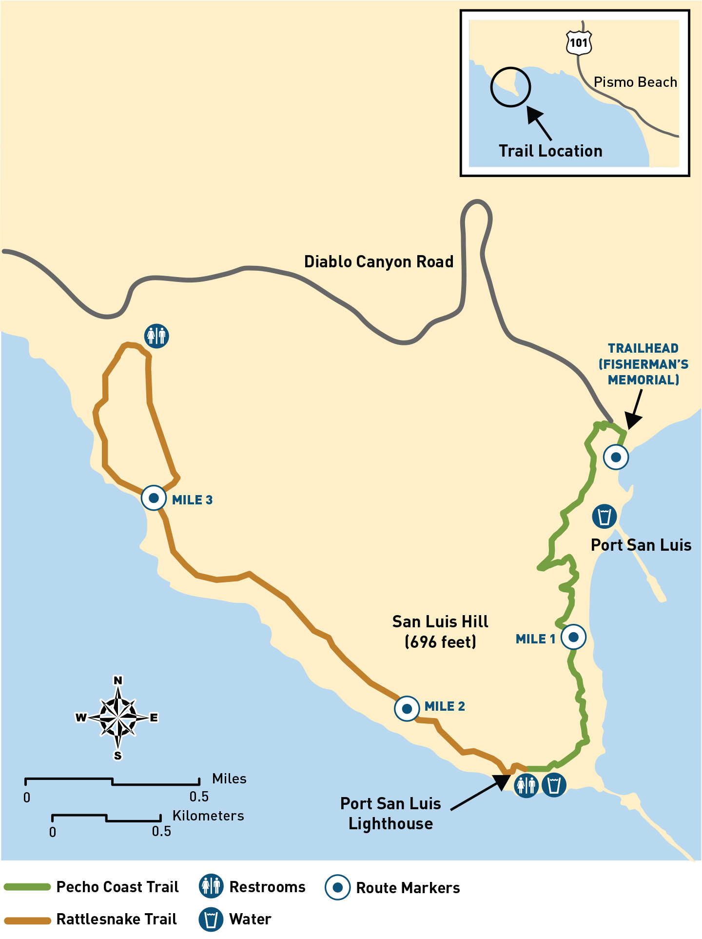
PG&E is proud to be the steward of over 12,000 acres located between Avila Beach and Montaña De Oro State Park in San Luis Obispo County. The land surrounds our power plant, Diablo Canyon. Through our Land Stewardship Program, PG&E preserves two hiking trails (Pecho Coast Trail and Point Buchon Trail) for visitors to see remarkable vistas of California’s central coast in its rugged, natural state

Learn about our hydroelectric system

Learn about hydropower and water safety

Reserve a campsite

To make reservations or find more information on our campgrounds and day-use facilities visit PG&E Reservation.
 

  • Reservations require a 2-night minimum.
  • Except for group campgrounds, all campgrounds have sites designated for first come, first serve use.
  • Please read all notices, rules & regulations before completing a reservation.
  • For questions contact the Recreation Help Desk via email at recinfo@pge.com.


Pecho Coast Trail

Learn about hiking on the Pecho Coast Trail

pecho coast trail logo

The Pecho Coast Trail is located on the south end of the PG&E property and accessed through Avila Beach. Choose from two guided hikes, the 3.75-mile roundtrip hike to Point San Luis Lighthouse and the 8-mile roundtrip hike to Rattlesnake Canyon.

This scenic coastal trail is a joint partnership between PG&E, the California Coastal Commission and the Port San Luis Harbor District. The hike takes visitors up to the Port’s Historic Point San Luis Lighthouse. Visitors can enjoy a short docent-led tour of the lighthouse by paying a $10 admission fee.

Pecho Coast Trail has been open for guided hikes since 1993 and is known for its panoramic views of Avila Beach. Hikers are treated to stunning landscapes while learning interesting facts from docent naturalists. Topics include the local history of the Avila Beach area and information on the Northern Chumash tribe who once inhabited the area.

The trail is home to many native plants and animals and interesting geological formations. Wildflowers are prevalent along the trail during the spring months, and California gray whales can be seen spouting offshore.

Reserve your spot

This docent-led hike requires a reservation. The Lighthouse Tour is now $10.

Register now

Dip into the past of Pecho Coast Trail

This pristine area is situated north of the Point San Luis Lighthouse and west of the Irish Hills on California’s Central Coast.

The Pecho Coast Trail has been open for docent-guided hikes since 1993. Before that time, the secluded beaches, rugged cliffs and broad coastal terraces of the Pecho Coast had been privately owned and had once been known as Rancho San Miguelito.

The wooded canyons, fertile headlands, lush shoreline and tide pools have provided human sustenance for at least 10,000 years. When the Spanish began exploring and settling along the Central Coast, Northern Chumash people inhabited the area. Their rich and varied culture was significantly impacted by the establishment of Mission San Luis Obispo de Tolosa in 1772. The Mexican Period (1822 – 1846) marked the first subdivision of lands along the Pecho Coast, which were split among very large land grants. PG&E works with Northern Chumash descendants to ensure responsible management of the coastline’s rich cultural resources.

The development of Port San Luis and its important shipping industry coincided with the increasing settlement of the area during the nineteenth century. The Point San Luis Lighthouse and breakwater were constructed in 1890 to maintain a safe port. These structures and many other sites of historic interest are visible from the Pecho Coast Trail.

Point Buchon Trail

Explore the pristine Point Buchon Trail

point buchon trail logo

Point Buchon Trail offers some of the most scenic views of the Central Coast coastline, perfectly preserved and protected. The trail is a 6.6-mile roundtrip hike located on the northern end of PG&E property and is accessed through Montaña de Oro State Park. This scenic coastal trail has been open to the public since 2007 and is known for its panoramic views of beautiful headlands and off-shore sea stacks.

PG&E follows predator-friendly ranch practices so that hikers may observe bobcats, coyotes, badgers and other wildlife. Golden eagles, peregrine falcons, and numerous hawk and passerine species are often observed flying above the coastal bluffs. In addition, the nearshore marine habitats and pristine tidepools support a wide variety of marine wildlife visible from the trail. Brown pelicans, black oystercatchers, southern sea otters and migrating grey whales are common sights.

Wildflowers flourish in the springtime, a benefit of PG&E's rotational grazing practices.

Visit Point Buchon at your leisure

The trail is open Thursday through Monday, year-round.

Please call ahead to the trailhead at 1-805-528-8758 to get the current trail status.

Dip into the past of Point Buchon Trail

Once known as Rancho Cañada de Los Osos y Pecho y Islay, this pristine area is situated just south of Coon Creek (Montaña de Oro State Park) and west of the Irish Hills on California's Central Coast. The scenic coastal trail has been open to the public since 2007.

The area around the Point Buchon Trail was occupied by Native Americans for over 10,000 years. The magnificent headland known as Point Buchon is named in honor of a prominent Northern Chumash leader so-named Buchon by the Spanish in 1769.

The land has been put to agricultural use since its days as a Mexican rancho. Crops were primarily grown on the coastal terrace, while livestock grazed in the hills further inland. During the 1920s and 1930s, much of the coastal terrace was leased to Japanese-American farmers. They continued to farm the land until 1942, when they were involuntarily relocated to internment camps established during World War II. Descendants of former tenant-farmers still visit the Point Buchon area and their story is memorialized on a trailside interpretive sign at Windy Point.

In 1942, Oliver C. Field acquired the Spooner Ranch. It included the lands that now comprise Montaña de Oro State Park, south to the present-day boundaries of Diablo Canyon Power Plant. Eventually, Field gave up farming because of difficulties in tapping enough water to irrigate his crops. While this coastal terrace is no longer farmed, rotational cattle grazing is currently practiced.

In 1976, Walt Disney filmed a portion of Pete's Dragon (1977) on a headland south of Point Buchon. A lighthouse was built for filming and equipped with such a large beacon that Disney had to get special permission from the Coast Guard to operate it. Although the lighthouse was dismantled, hikers on the Point Buchon Trail can see the filming location at the aptly named "Disney Point."

Frequently asked questions

Make planning your next trip easy. Learn about locations, what’s available at each site, fees, camping and more.

More about recreational areas

Check the weather

Be prepared for changeable conditions.
Weather in Avila Beach
Weather in Los Osos

Visit local websites

Charming towns, historic sites. Find what these unique areas have to offer.
Avila Beach
Montana de Oro Park
Point San Luis Lighthouse